Tongariro National Park’s wildfire remains active today with mist limiting growth overnight but also grounding aircraft this morning while crews worked on the ground.
The fire was last estimated at about 3,000 hectares.

Fifteen helicopters and five fixed-wing aircraft are on standby to resume drops, with eight FENZ crews from Wellington and Hawke’s Bay joining seven DOC crews and additional local volunteers to bolster the ground attack.

Whakapapa Village was evacuated yesterday as the blaze expanded across difficult terrain on the Central Plateau.
Authorities report partial containment on some flanks but continue to warn that wind shifts could change conditions quickly.
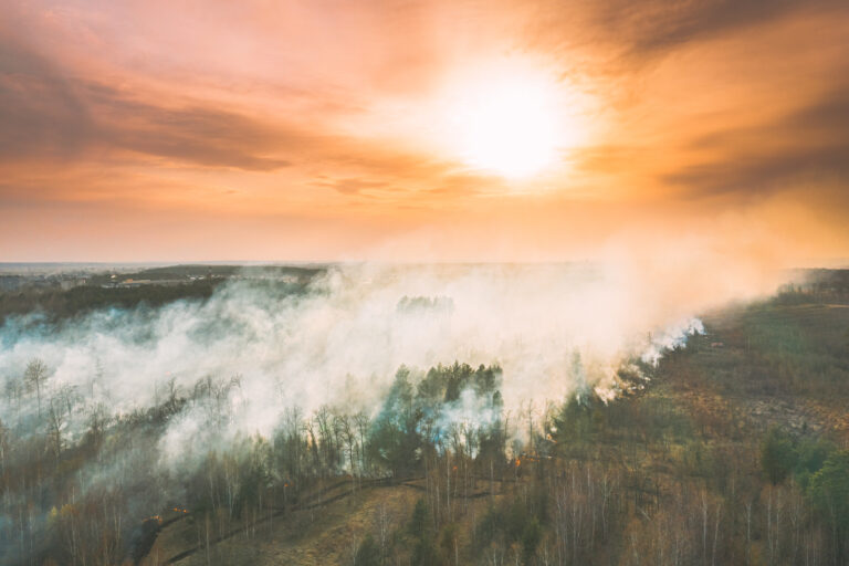
The latest photos provided by FENZ show the scale of devastation caused by the wildfire.

Photos from across the North Island overnight also show a prominent smoke column visible well beyond the park.
This photo below was captured from Urenui overnight by Haidee Beale, along with others submitted to our Photos of Taranaki community group on Facebook.

Road closures have been extended: State Highway 47 and State Highway 48 remain closed between SH4 and SH46 at Waimarino, with NZTA advising the closures are likely to remain in place for at least the next two days while suppression continues. Drivers should avoid the area and monitor official updates before travelling via the NZTA Journey Planner.

DOC has closed the Tongariro Alpine Crossing and parts of the Northern Circuit.
A temporary no-fly zone remains over the fireground to keep firefighting aircraft safe from drones and private aircraft.

Public are asked to stay clear of the park, follow instructions from emergency services, and keep doors and windows shut if affected by smoke.